1.
Walk
from Stow-on the Wold to Bourton-on the-Water
About 4.5 miles mostly level, stopping at Lower Slaughter Mill
and Museum. You set out down the Fosse Way (A429) till you
reach the footpath sign for the Gloucestershire Way. Walk down the lane
with fine views till you get to a farm with an equestrian
centre. From here you take the path across a field to reach
Hyde Mill. From this delightful spot you cross the bridge and
head through the meadows on level ground close to the little
river Dikler. Following the waymarkers as you go (there are 4
major footpaths here!) take the Macmillan Way which will eventually
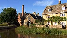
bring you to Lower Slaughter church. From here you follow the
road round then right to see the classic picture book scene:
idyllic cottages lining the river Eye, and of course the Old
Mill ...where you can take tea. It is just a mile and a half
then on the Heart of England Way to Bourton, crossing over the Fosse Way
and down the lane through the Cotswold School grounds into
town. No shortage of places to eat and drink at Bourton! There
is a bus to Stow (Pulhams Coaches no.801) you can catch from
the stop outside the Edinburgh Woollen Mill, back to
where you started.
GOOGLEMAPS
plotted trail ~ walk 1

2.
Circular
Walk from Bibury (Jubilee Walk)
About
4 miles undulating through farm tracks, woods and fields but
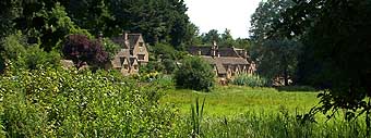
quite easy and very scenic. You set out from the picturesque
little village missing out Arlington Row beacause
you will encounter these beautiful cottages on your return.
Have a look at the little church before passing by Bibury
Court Hotel. You pass over the River Coln on a mill
bridge, past a farm, then down a long dry-stone walled lane into
woods. After a mile or so you cross a pleasant meadow with
sheep, then join another lane and cross the route of the Roman
Akeman Street, although there is no trace of it now. At
the end of the lane are cottages which mark the half-way
point. The jouney back to Bibury passes an ancient dew-pond
and skirts around grain fields with lovely hedgerows and some
really classic undulating Cotswold countryside. After a sharp
turn right, the grassy track leads you back over a stile and
downhill to Arlington Row and all the attractions of Bibury
once more. A very pleasant couple of hours away from the
crowds.
JUBILEE
WALK
~
BIBURY
and the River Coln
(printable)
3.
Broadway
to Toddington
About
6 miles with great views (some ascents and descents but not
too strenuous)
ending at the famous Cotswold GWR steam railway. Leaving
Broadway on the Snowshill road, you join the Cotswold Way on
the right which takes you over sheep fields to West End. Fom
here you follow the Way up and around another field
...but do stop and look back behind you as you climb, all of
Broadway and the Vale of Evesham begs to be noticed. After a
copse you bear right, away from The Cotswold Way, to the flat
site of Burhill Iron-Age Fort, with more superb almost 180º
views. Then it's down to the tiny village of Buckland with an
almost deserted church and the opulent Manor Hotel. Cross more
sheep fields as you walk to the next village of Laverton, with
some fine old cottages and gardens. Leaving at the top of the
village you make your way along the scenic Winchcombe Way
crossing the side of the escarpment to the beautiful and
largely unspoilt village of Stanton, with houses made
from the deepest coloured stone you are likely to encounter in
the Cotswolds. There is a pub here at the top of the village: The
Mount Inn (check opening times-we didn't!). Leaving lovely
Stanton, cross sheep fields back on the Cotswold Way to
the neighbouring village of Stanway, famous for its Manor
House and spectacular fountain. The gatehouse next to
Stanway's church is very imposing. After such a scenic
trail you end up taking a rather ordinary road walk along the
B4077 to the steam railway village of Toddington. Refreshments
at the station, or the Pheasant Inn at the crossroads.
Cotswolds
Trail
3
plotted on GoogleMaps
You can email us at:
grindelwald_prods@lycos.com
|
4.
Circular
Walk from Winchcombe to Belas Knap
 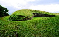
4-5 miles, quite steep at times... but all downhill coming back!.
A recommended short trail on the Cotswold Way taking in the
wonderful neolithic burial chamber, Belas Knap. Depart Winchcombe via Vineyard Street with its lovely stone cottages. You
begin the trail at a stile just over the stone bridge, which
leads you to a footpath alongside the village to a lane and a
cricket field. From here you climb steadily through pasture
with horses, to a kissing gate on Corndean Lane above. Behind
you is a view you cannot ignore: the whole of Winchcombe and
the rolling hills surrounding, marvellous! From here you go
along and up through woodland then make a steep climb through
sheep fields to the famous and very well-kept burial chamber.
After a rest and a look round you could carry on to Hill Barn
Farm, but we retraced our steps to the Corndean Lane, then on to the
delightfully named Humblebee Cottages. A wonderful
vista of Sudeley Castle and the curvacious Cotswold escarpment
opens up here. It is a steady downhill trail now through
farmland back to Vineyard street where you began. There are, of
course, plenty of opportunities in Winchcombe for
refreshment.
Belas
Knap Circular Walk
Suggested circular walk (printable)
5.
Cotswolds
Escarpment walk from Crickley Hill
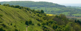
5.5
miles, undulating and following the Cotswold Way ...with
fine views. We parked our car at Coopers Hill (the end of our
walk) then arranged a taxi to drop us off near Shurdington
Hill, but you could easily start at Crickley Hill Country Park
and make a shorter trail. This is a good taster of the Cotswold
Way if you ever decide to walk the entire National Trail.
Passing through ancient leafy beechwoods along the top of the
Cotswold escarpment, you soon arrive at Crickley Hill
(228m) where you can take in spectacular views of not only
Gloucester and Cheltenham, but the mountains in Wales far
beyond. Also on this hill are the earthworks of an Iron-Age
village with fascinating interpretation boards. Taking a sharp
left turn you follow the Cotswold Way to the
interestingly-named Air Balloon pub, and could probably
fit in a swift drink. It can be a noisy spot because it is
situated at the junction of two major roads into Gloucester.
From here you follow the undulating escarpment and gradually
descend into pleasant woodland for 2 miles with just
occasional glimpses out across the Gloucester vale. With a
chance to see the site of a Roman Villa (we didn't) you carry
on to the site of the famous and crazy annual Cheese
Rolling Event at Cooper's Hill, held at the end of May.
There is a small car park here where we left our car.
Cotswolds
Trail 5 plotted on GoogleMaps
6.
Walk
into Bath
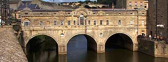
This
is the classic end of the Cotswold Way
~ 6 miles mostly downhill from the
Landsdown Racecourse, but a few short
climbs as you enter the suburbs of Bath. The trail starts very
conveniently at the Landsdown Park & Ride so you can
return back to this spot by bus after you have completed this
lovely walk. Starting at the Blathwayt Arms you see
Bath's famous racecourse, and yes, you have to walk across it,
ducking under the railings... there might be other
arrangements in season if a race is being held! Possibly the best viewpoint of the whole of the
Cotswold Way is to be found at Prospect Stile before you
descend steadily along the hilltops and fields into the Georgian city. When you arrive the
suburb of Weston, the trail doesn't take you along the main
roads, it meanders up and over, delightfully through parkland,
and to Sion Hill, an older part of Bath. Then it takes you
down through a golf course into Victoria Park, and past
magnificent and iconic Royal Crescent and then the Circus...
Not far then down Gay Street into the city centre, ending at
the wonderful Bath Abbey. Highly recommended!
Journey's
End Walk to Bath Suggested circular walk
(printable)
|